Find Your Daily Voice
Tags
Follow
News
Schools
Business
Obituaries
Police & Fire
Weather
Neighbors
Lifestyle
Politics
Sports
Events
Traffic
Legal
Real Estate
Tags
Jobs
Shop
Support Us
Follow
Find Your Daily Voice
News
Schools
Business
Obituaries
Police & Fire
Weather
Neighbors
Lifestyle
Politics
Sports
Events
Traffic
Legal
Real Estate
Tags
Jobs
Shop
Support Us
Home
About us
All sites
Advertise with us
Contact us
Terms of use
Privacy policy
Code of ethics
Site Map
© 2024 Cantata Media
Tag:
Storm
Arlington
Weather
Drenching Rain, 45 MPH Winds: New Storm Moving Toward Northeast
Forecasters are warning of a weekend storm bringing widespread rain and gusty winds to the Northeast, creating yet another flood risk. Thursday, March 7 will be be mild with scattered showers while Friday, March 8 will be mostly sunny with temps in the mid-50s, forecasters say. Saturday, March 9 is when the new storm will begin moving into the region with rain beginning in the afternoon and lasting overnight, according to the National Weather Service. About an inch of rain is expected to fall, which the National Weather Service says isn't much, but given an already-wet ground "there is pot…
White Plains
Weather
72 MPH Wind Gust Reported During Storm: Here's Rundown From Region
Did you hear it howling overnight? You're not alone. Widespread 40 to 50-mile-per-hour wind gusts were reported across the region as a powerful storm accompanying a frontal system swept through the Northeast. The highest reported gust -- at 72 miles per hour -- happened on Long Island just before 12:30 a.m. Thursday, Feb. 29 on top of a building in Stony Brook at 159 feet, according to the National Weather Service. Here are more wind-gust reports from locations in New York and Connecticut. Location Speed Time/Date Provider New York Nassau County …
Yonkers
Police & Fire
Video: Woman Rescued From Submerged Vehicle On Flooded Bronx River Parkway In Yonkers
Authorities have shared a nail-biting video depicting a dramatic rescue of a woman from a flooded parkway in Westchester during a powerful storm event. The rescue happened on Tuesday night, Jan. 9, when the Yonkers and Westchester County Police Police Department learned that a woman had become trapped inside her vehicle in rapidly rising floodwaters on the Bronx River Parkway in Yonkers during a severe storm on the same night. According to Yonkers Police, the department's Emergency Service Unit then put on their water rescue suits and deployed their rescue boat to reach the trapp…
Arlington
Weather
'Arctic Blast:' Snow, Ice To Threaten Northeast After Windy, Rainy Start To Weekend
Forecasters are tracking two more storms in the coming days: One bringing heavy rain and wind, the other snow and ice to the Northeast. Thursday, Jan. 11 will be partly sunny with a high near 45 while Friday, Jan. 12 will be the same, before rain begins in the evening, the National Weather Service says. The heaviest rain will fall at night and could result in major flooding adding to the damage for the mid-week storm. Quieter conditions are expected today before the next system arrives Friday afternoon into the weekend. Expect another... Posted by US National Weather Service Bal…
White Plains
Traffic
Storm Flooding Causes Closures Throughout Busy Parkways In Westchester: Here's Where
This story has been updated. Thanks to a massive storm system that dumped inches of rain on Westchester, busy parkways within the county are affected by various closures caused by flooding. The closures, which have resulted from a storm that brought 2 to 3 inches of rain to the region on Tuesday, Jan. 9 into Wednesday, Jan. 10, are affecting the Bronx River and Saw Mill River Parkways, Westchester County Police announced on Wednesday morning. Related Report - Massive Storm Causes Flooding, Road Closures, Power Outages, School Closures, Delayed Starts These closures curren…
Mercer
Police & Fire
Storm Flooding, Road Closures, Downed Wires Persist In Mercer County
Police and firefighters continued to grapple with flooding, area road closures and downed power lines following the storm. Scattered power outages persisted throughout Mercer County where more than 700 homes and businesses remained without power early Wednesday, Jan. 10, according to Jersey Central Power & Light. Among roads that remained closed early Wednesday included: Mercer Road between Province Line Road and Lovers Lane in Princeton remained closed due to flooding. Washington Road was closed westbound in West Windsor. The eastbound lane had reopened. There were still utility haza…
Essex NJ
Weather
Another Storm Nears: Weather Service Warns Of Event Causing More Flooding In NJ, PA
Yet another storm system is working its way toward the region, the National Weather Service warns. Northern New Jersey and Southeast Pennsylvania will remain in a flood stage through the end of the week, when the second storm is set to arrive, the NWS said. That storm will begin Friday evening, Jan. 12, with rainfall continuing overnight into Saturday, Jan. 13, the weather service said. That storm will also be accompanied by new flooding and damaging winds. While recovery is underway from the storm that affected our region last night, another storm is gearing up to affect our... Posted…
Baltimore
Lifestyle
Tens Of Thousands In DMV Without Power With New Round Of Rain Approaching
Tens of thousands of residents throughout the DMV region are in the dark as whipping winds and heavy rains have knocked out power to some neighborhoods and businesses. With the worst of the storm yet to come, as of 7:30 p.m. on Tuesday, Jan. 9 Baltimore Gas and Electric crews were still working to repair 720 active outages impacting 34,513 of the company's 1,348,380. A breakdown, by county, at 7:30 p.m.: Baltimore: 12,513 customers affected; Anne Arundel: 7,390; Howard: 6,532; Prince George's: 2,762 Baltimore City: 2,537; Harford: 1,511; Carroll: 1,101; Calvert: 111; Montgomery: 27.…
Warren Hunterdon
Weather
Tracking Weekend Snow, Mid-Week Rain Storms Both Heading Toward Northeast
Parts of the region will be shoveling out of several inches of snow from the weekend when another strong storm system moves in, forecasters are saying. On Friday, Jan. 5, the National Weather Service released a new model showing between eight and 12 inches of snow in Sussex and Warren counties in New Jersey, and the Pocono mountains in PA (scroll for map). The chance of snow isn't looking good for greater Philadelphia this weekend, the NWS says, noting snow-lovers in the area will be "disappointed" by this weekend's system. "Our latest forecast has only a 3% chance of seeing 1" or more of …
Arlington
Weather
Another Impactful Storm To Follow Snowy Weekend In Northeast: Forecasters
Forecasters are touting a massive storm expected to drop several inches of snow on the East Coast this weekend. But some weather maps show parts of the Northeast will get only rain, and no snow at all, noting a another impactful storm could be coming mid-week next week, AccuWeather reports. The storm coming Saturday, Jan. 6 will move northeast from the Gulf Coast toward the mid-Atlantic between 12 and 1 p.m., according to AccuWeather and the National Weather Service. Our first chance for some accumulating and potentially impactful snowfall this season will occur for some this wee…
Arlington
Weather
Midweek Downpours Expected To Bring 3 Inches Of Rain, Travel Delays To East Coast
A new storm system tracking along the East Coast is expected to drop several inches of rain on the region in the next two days, meteorologists say. Rainfall is expected to begin along the mid-Atlantic Tuesday night, Dec. 26, and make its way north through Pennsylvania, New Jersey and the New York City area on Wednesday afternoon, Dec. 27. Flooding and travel delays are to be expected from Virginia to New England, the Passaic, Ramapo and Raritan rivers in New Jersey most likely to experience flooding, according to AccuWeather. This is not good news for municipalities across Passaic County w…
Norfolk
Police & Fire
Flooding, Power Outages Plague Mass After Storms Pummel Northeast
Heavy downpours led to widespread flooding and power outages across eastern Massachusetts on Monday, Dec. 18, and it could be days before authorities can restore electricity to all homes. More than 270,000 people were left without power as of Monday afternoon, the Massachusetts Emergency Management Agency (MEMA) said. Bad weather also led to more than 200 flight cancellations at Boston Logan Airport, according to FlightAware, with more than a third of flights coming to or leaving from the airport delayed. Cities in Plymouth and Bristol counties felt the brunt of the storm, with over 9…
Briarcliff
News
Amid Downpours, Briarcliff Manor Residents Told To Conserve Water
As rain pounds the region and the wind howls, one Northern Westchester municipality is being told to conserve water after a large main break. The break occurred in the village of Briarcliff Manor around 5 a.m., Monday, Dec. 18 along Sleepy Hollow Road, leading to a disruption in water supply and pressure for residents along the roadway. Related story: Potent Storm With Drenching Rain, Damaging Winds Causing Power Outages, Flooding, Road Closures As of 8:30 a.m., officials with the Briarcliff Manor Public Works Department said crews, working in the downpours, have located the break a…
Burlington
Weather
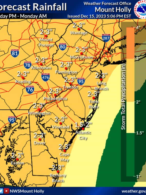
Murphy Warns NJ Residents To Prepare For Heavy Rain, Flooding, Strong Winds
New Jersey Gov. Phil Murphy is warning residents of a powerful storm expected to slam the region this weekend. The "powerhouse" storm expected to arrive on Sunday afternoon, Dec. 17 will have the look and feel of a tropical system, AccuWeather says. ⚠️ Weekend weather warning ⚠️ Prepare for heavy rain 🌧️, flooding 💧, and strong winds 💨 Sunday into Monday across the state.Stay safe, NJ! — Governor Phil Murphy (@GovMurphy) December 16, 2023 A flood watch has been issued for nearly the entire state, along with greater Philadelphia and the…
Arlington
Weather
'Deja Vu:' Another Storm With Heavy Rain, Gusty Wind Takes Aim At East Coast
Meteorologists are tracking another storm headed to the region early next week. This storm could look a lot like last weekend's storm, which brought several inches of rain, snow, and gusty winds to the region, AccuWeather says. "For millions, it will end up being a case of déjà vu," AccuWeather Senior Meteorologist Joe Lundberg said. "This next storm coming up the Eastern Seaboard will have similar characteristics to the one that slammed the mid-Atlantic and Northeast with heavy rain and wind just days ago." The rest of the week will be sunny with increasing temps, and dry. But come S…
Union
Weather
Hundreds Without Power In These Morris, Warren, Burlington County Towns
Hundreds of New Jersey residents were left in the dark following the storm that swept through the region over the weekend. Gusty winds blew across the region Monday, Dec. 11, as hundreds waited for power to be restored. ALSO SEE: These NJ Towns Saw The Most Snow, Rain In Weekend Storm According to JCP&L, the following customers were without power as of 10:15 a.m. Monday, Dec. 11: Hunterdon County: 433 (East Amwell, 95; Lebanon, 165; High Bridge, 38). Restorations vary between 11 a.m. and 2 p.m. Morris County: 292 (Chester, 47; Harding, 55; Morris Twp., 115; Randolph, 33). Restoration…
Union
Weather
Powerful Storm Could Disrupt Travel In New Jersey This Weekend: Here's The Timing
A powerful storm is set to bring heavy rain and travel disruptions to New Jersey this weekend. The week will be clear with temps in the mid-40s through Friday, Dec. 8, when we'll see a bit of a warmup, according to the National Weather Service. We will have a cool next couple of days before a warm-up to finish off the week! The next chance for rain will arrive late Saturday night into Sunday. Look up your local forecast at weather.gov/phi/ Posted by US National Weather Service Philadelphia/Mount Holly on Tuesday, December 5, 2023 Friday will be sunny with a high of 55, with Saturda…
Yonkers
News
$1M Lottery Win: Lucky Second-Prize Mega Millions Ticket Bought At This Yonkers Store
Amid a devastating storm that left much of the region flooded, one lucky lottery player made a purchase at a Westchester store that will likely change their life forever. A second-prize-winning Mega Millions ticket worth $1 million was sold in Yonkers for the drawing on Friday night, Sept. 29, the same day as a freak weather event that brought several inches of rain along with it, according to New York Lottery. Earlier Report - Record-Breaking Rainfall: These Are Highest Totals From Severe Storm, 5-Day Forecast Lottery officials announced that the lucky ticket was bought at the…
Hampden
News
Palmer Man Killed By Falling Tree While Camping With Fiancée In Vermont ID'd
A 33-year-old Hampden County man on a camping trip in Vermont was killed on Friday, Sept. 8, when a tree fell on him during a storm, authorities said. Joshua Przybycien, of Palmer, was camping with his fiancée, Kathryn Workman, in Somerset, Vermont, when high winds and heavy rains toppled the tree around 1 a.m., Vermont State Police said. No one else was injured. Related: Community Rallies Around Palmer Man Killed By Falling Tree Adam Przybycien posted on Facebook that Joshua was "kind and loved by all." Long Live Joshua Przybycien. I Love you man it still don’t feel real and it …
White Plains
Weather
New Rounds Of Storms With Strong Winds, Drenching Downpours Could Cause More Power Outages
More potentially severe scattered thunderstorms are expected to sweep through the region this weekend after previous activity resulted in downed trees and thousands of power outages the previous two days. The next window for storm activity is in the afternoon and evening on Saturday, Sept. 9. The main threat will be damaging winds, with additional threats for isolated large hail and flash flooding triggered by drenching downpours, according to the National Weather Service. Humid conditions will linger Saturday, but it won't be as hot as it has been the last several days, with a …
Hackensack
Police & Fire
Fully
Involved
: Downed Wires Ignite Minivan On Route 46
Wires downed during Friday afternoon's storm set a minivan on fire on Route 46. The vehicle ignited at the corner of Huyler Street and the highway in Teterboro, across from the airport, shortly before 4 p.m. Sept. 8. Smoke billowed across the street, momentarily stopping traffic just as the Friday evening rush was about to heat up (no pun intended). No injuries were reported. Smoke billowed across Route 46 across from Teterboro Airport.MOONACHIE PD Hasbrouck Heights firefighters extinguished the fully-involved blaze after power was cut to the wires. Little Ferry firefighters provided …
Prince William
Obituaries
Falling Tree Kills Marine Corps Web Developer In Montclair
Support was surging for the family of a Virginia man killed by a falling tree this weekend. Not only did the Lee family lose its home, they lost its patriarch. Kenneth Allan Lee, Jr., a web developer for the U.S. Marine Corps, died on Sunday, July 30, when a tree fell on his Holly Hill Drive home amid a "tornado-like" storm, according to a GoFundMe for the family and county police. Lee, 43, leaves behind his wife, Rachel, and daughters, Matilda and Amelia. *INCIDENT: Death Investigation | Dumfries; #PWCPD is currently investigating the death of a 43-year-old man possibly... Posted by…
Fairfax
Weather
Potent Storm Nears: Here's When Damaging Wind Gusts Could Cause Power Outages
Damaging wind gusts that could cause power outages will be the main threat from a potent storm system that will sweep through the region. It's on track to arrive overnight Friday, March 31 into Saturday, April 1, with scattered thunderstorms at times through early Saturday evening before the system moves out, according to the National Weather Service. Wind gusts during the height of the storm will be as high as 50 to 60 miles per hour. (See the first image above from AccuWeather.com). Ahead of the storm, Friday, March 31 will be mostly cloudy with a chance of showers s…
Cape May
Weather
It's Time To 'Spring Forward,' But Storm Packed With Strong Winds Is Coming
We're just hours away from the start of Daylight saving time with clocks moving ahead one hour at 2 a.m. Sunday, March 12. Though it's "Spring Forward" time, a potent storm that will be packed with a mix of snow, sleet, rain, and strong winds that could cause power outages is headed to the region. The time frame for the storm is Monday, March 13 into Tuesday, March 14, according to the National Weather Service. A look at projected snowfall totals from the early week Nor'easter.AccuWeather.com It will be the second winter storm in the span of days as the weekend is off to a messy storm…
Norwalk
Weather
New Winter Storm Expected To Bring Snow, Sleet, Rain, Cause Slippery Travel
A new storm headed to the region is expected to bring a mix of snow, sleet, and rain that could cause slippery travel conditions. The time frame for the system is late Monday night, March 6 into Tuesday morning, March 7, according to the National Weather Service. Leading up to the storm's arrival, Sunday, March 5 will be mostly sunny with a high temperature in the mid to upper 40s. Monday will start off with clear skies as the high temperature climbs to around the 50-degree mark. Clouds will increase at night ahead of the storm's arrival. Areas where the overnight temperature stays…
Nassau
Weather
These Areas Could See Snowfall From Potent Storm Headed To Northeast
A complex new storm on track for the Northeast is expected to bring a mix of rain, sleet, and snow. Ahead of the arrival of the system, there will be a return to warmer-than-normal temperatures for this time of year Sunday, Feb. 19, and Presidents Day on Monday, Feb. 20 into Tuesday, Feb. 21, according to the National Weather Service. High temperatures during that street will range from the upper 40s to low 50s with cloudy skies each day, Showers are possible both Monday and Tuesday, with some areas seeing snow showers overnight Monday into Tuesday morning. The potent stor…
White Plains
News
Approaching Front Will Bring Rain, Heavy Wind Gusts Ahead Of Coastal Storm: Here's Timing
An approaching frontal system will move across the region, bringing a new round of precipitation ahead of a more significant coastal storm whose projected track has now pivoted farther south. The warm front is due to arrive around midday on Thursday, Feb. 9, which will be mostly cloudy throughout the day with a high temperature ranging from the upper 40s to around 50 degrees, according to the National Weather Service. There will be rain at times during the afternoon and into the evening on Thursday, with wind gusts up to around 20 miles per hour, increasing in speed overnight to around…
Putnam
Weather
Storm Watch: Fast-Moving System Brings Rain, Sleet, With Up To Foot Of Snow Farther North
A complex storm is bringing rain to much of the region, with sleet farther inland, and as much as a foot of snow in some spots in upstate New York and northern New England. The storm, which arrived late Sunday afternoon, Jan. 22, has continued into Monday morning, Jan. 23. The storm is expected to wind down late in the morning or around midday on Monday, with skies gradually clearing on a brisk and breezy day with a high temperature in the upper 30s to low 40s, according to the National Weather Service. "For snow lovers in and near the big I-95 cities in the Northeast, this is another disa…
Ulster Sullivan
Weather
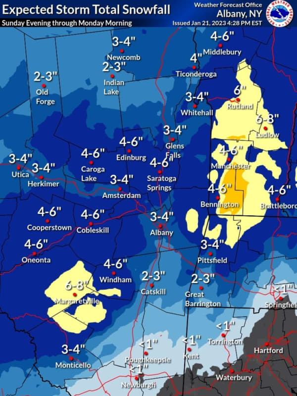
New Update: These Areas Could See Up To 8 Inches Of Snowfall From Complex Storm System
A complex storm sweeping through the region could dump as much as 8 inches of snowfall to parts of the region. The storm is expected to move from the south to the north starting late in the afternoon on Sunday, Jan. 22, and continue into the overnight through Monday morning, Jan. 23, according to the National Weather Service. Anywhere from 3 to 8 inches of snowfall accumulation is possible in the areas shown in the first image above. Areas farther south expected to see a trace or more of snow are shown in the second image above, in the upper left corner. Related story: Midweek Storm…
Fairfax
Weather
Midweek Storm Will Be Second To Sweep Though Region This Week: Here's Latest On Both
Back-to-back storms will sweep through the region in the span of days, bringing separate rounds of rain, sleet, and snow. The first system is on track for Sunday afternoon, Jan. 22 into Monday morning, Jan. 23. The second system of the week is due to arrive on Wednesday, Jan. 25. (See the first image above from AccuWeather.com.) Accumulating snowfall is expected in interior portions of the Northeast from both systems. Sunday will be cloudy throughout the day with a high temperature in the low 40s before the storm's arrival late in the afternoon. Most of the region will see rainfall (…
Stamford
Weather
Storm Could Bring Up To Foot Of Snow To Parts Of Northeast: Here's What To Expect
A new storm taking aim at the Northeast could bring up to a foot of snow to some spots in northern New York and New England. The system is due to arrive on Thursday, Jan. 19 before exiting during the morning on Friday, Jan. 20. For projected snowfall totals, see the first image above from AccuWeather.com: 6 to 12 inches of snowfall in the areas shown in royal blue, 3 to 6 inches in the areas shown in Columbia blue, 1 to 3 inches in areas shown in sky blue. Most of this region will see mainly rain. (Click on the second image above.) About an inch of rainfall is expected in…
1
2
3
4
5
6
7
8
9
10
Archive