Find Your Daily Voice
New Forecast: Increased Snowfall Totals Expected, Arctic Temps To Follow Northeast Storm
Newly-released forecast maps show parts of the region could see up to six inches of snow in the end-of-week storm.
Intermittent snow is expected to begin between 4 and 7 a.m. Friday, Jan. 19, with the heaviest amounts falling in the afternoon, the National Weather Service said.
Snow will fall at about 0.5 inches per hour and will taper by the evening, with temps in the upper 20s and low 30s, the NWS said.
SNOWFALL PREDICTIONS
The areas expected to get 4 to 6 inches are Trenton, Long Branch, Allentown, and Philadelphia. Reading, Vineland, Parsippany and Toms River are expected to get 3 to …
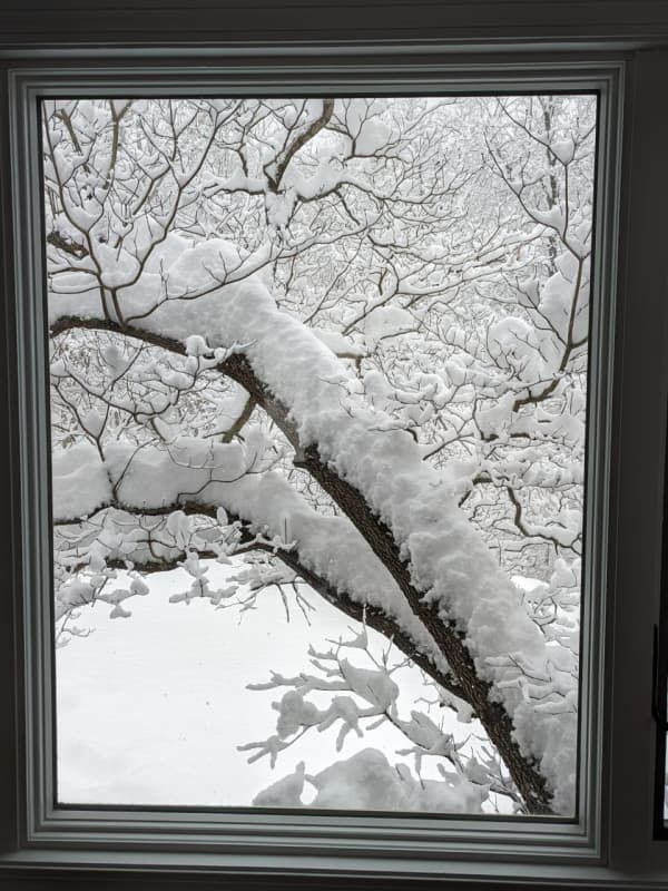
Here's Who Got The Most Snow In Bucks County
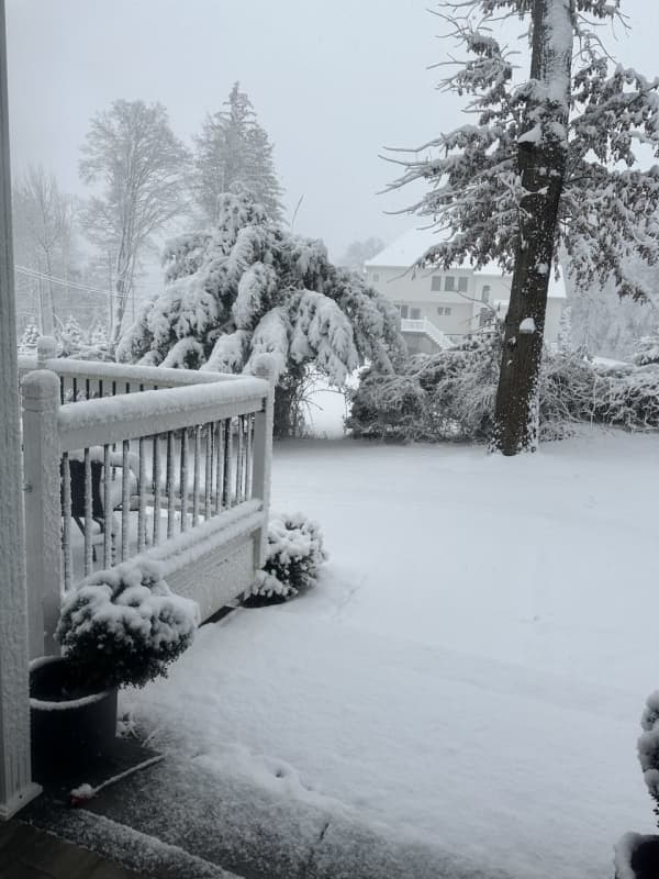
Greater Philadelphia woke up in a winter wonderland Tuesday, Jan. 16 as a wintry system worked its way up the eastern seaboard Monday night, Jan. 15, and into the early morning hours.
Though the snowfall has mostly tapered off, winter weather advisories remain in effect as of 3 p.m. Tuesday for Berks, Bucks, Chester, Delaware, Lehigh, Montgomery, Northampton, and Philadelphia counties, said the National Weather Service.
Here's how snowfall totals stacked up across the region in the last 24 hours, according to NWS meteorologists.
Berks County had its highest snowfal…
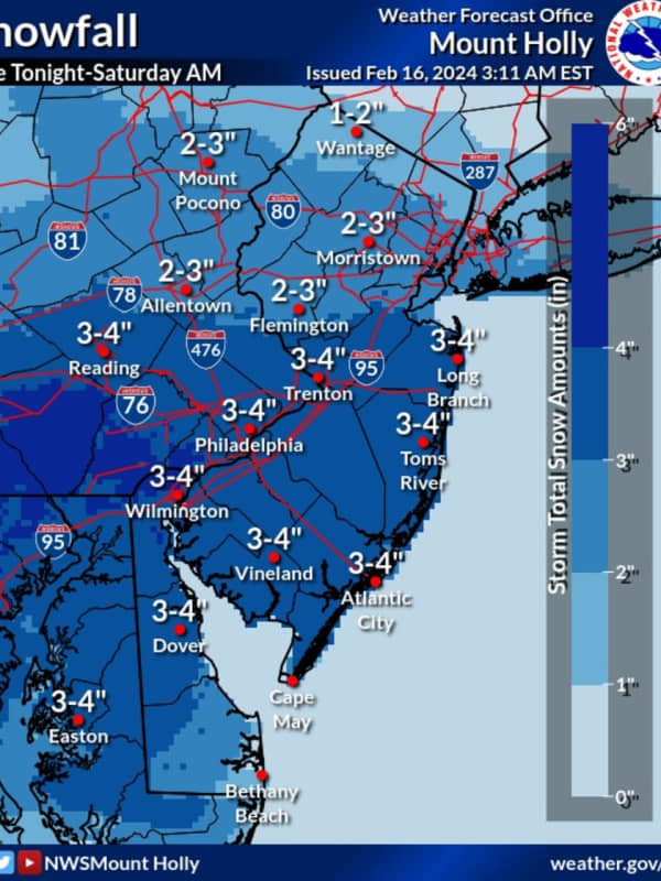
Six Inches Of Snow Could Slam Parts Of NJ, PA: Latest Forecast, Timing Updates
Newly-released forecast maps from the National Weather Service show up to six inches of snow could fall across eastern Pennsylvania and much of New Jersey.
Accumulating snowfall will begin Monday, night Jan. 15, mainly after 7 p.m., and carry into Tuesday morning, Jan. 16, impacting the morning commute as it changes over to a wintry mix, the NWS said in its latest briefing.
ALSO SEE: North Jersey School Delays For Tuesday, Jan. 16
Between 4 and 6 inches of snow was being forecast for most of North Jersey (including Morris, Sussex, pars of Bergen/Essex/Hudson, Warren, and Hunterdon Counties…
Sunday Snow Squalls Possible In Parts Of DMV Region, Forecasters Caution
Another storm may bring upwards of an inch of snow to parts of Maryland, Virginia, and DC on Sunday, according to forecasters.
While the DMV region won't face the same perils that forced the NFL to postpone the Buffalo Bills playoff game in upstate New York, some parts of the area may see a wintry mix on Jan. 14 as they celebrate the holiday weekend.
Temperatures began cooling down on Saturday, with a cold front heading in that could bring whipping winds, some snow showers, and other inclement weather, officials say.
Behind a cold front, temperatures will cool off through the day. This …
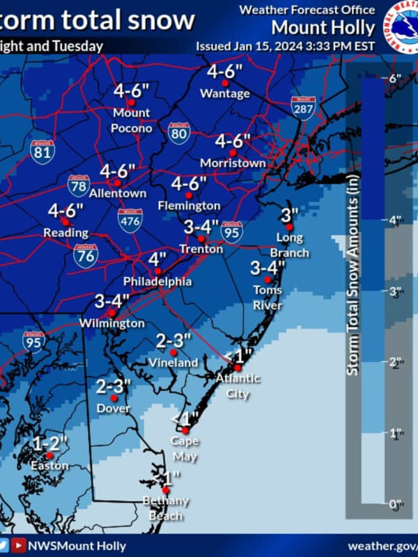
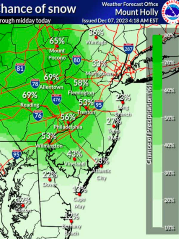
Snow Predictions Increase From National Weather Service For Parts Of NJ, PA (Timing)
The National Weather Service has released its latest snowfall predictions for New Jersey and parts of eastern Pennsylvania ahead of this weekend's storm.
HOW MUCH SNOW?
Good Saturday morning. It is a cold start to the day, however a storm arriving by later today will bring accumulating... Posted by US National Weather Service Philadelphia/Mount Holly on Saturday, January 6, 2024
Up to a foot of snow is expected to fall in Sussex, Morris, Passaic, and Warren counties, and even a small portion of northwestern Bergen County, beginning Saturday afternoon, Jan. 6, the NWS' latest weathe…
Winter Storm: North Castle Police Urge Residents To Hunker Down, Stay Off Roads
Ahead of a potent winter storm predicted to bring several inches of snow to the Hudson Valley, officials and police departments are urging residents to prepare for the white stuff, sign up for emergency alerts, and keep roads and sidewalks clear.
Officials and police in both Westchester and Putnam Counties issued the warnings on social media ahead of a storm predicted to arrive in the region on Saturday evening, Jan. 6, and continue into Sunday, Jan. 7.
As of Friday morning, Jan. 5, the storm was predicted to bring around 8 inches or more to Westchester and Putnam, according to …
Winter Storm - Hochul Warns NYers To Prepare For Snow, Possible Power Outages: 'Be Vigilant'
As a powerful Nor'easter threatens to dump inches of snow and a wintry mix on much of New York State, Gov. Kathy Hochul is urging residents to prepare for power outages and travel hazards posed by the white stuff.
According to Hochul, the large coastal weather system is predicted to hit New York late Saturday, Jan. 6, and continue into Sunday, Jan. 7, bringing anywhere from 3 to 12 inches of snow to parts of the Hudson Valley, Capital Region, and Central New York, and a mix of snow and rain to New York City and Long Island.
Winter storm watches are in effect throughout New York S…
Expect Snow In Quick-Hitting New Year's Storm: Forecasters
A quick-hitting storm is expected to bring snow showers to parts of Pennsylvania, northern Maryland, and northwest New Jersey, on New Year's Day, forecasters say.
The Alberta Clipper, named after the "lightning-fast" sailing vessels of the Canadian province, is already working its way into the region from the Great Lakes, AccuWeather says.
Any remaining precipitation will end this evening as high pressure builds across the region. An approaching cold front... Posted by US National Weather Service Pittsburgh PA on Saturday, December 30, 2023
Quiet and seasonable through Sunday, …
Post-Thanksgiving Storm Strengthens As It Heads Toward Northeast
A coastal storm intensifying in the mid-Atlantic will bring widespread rain with sleet and snow in some interior locations in the Northeast at the tail end of Thanksgiving weekend, affecting travel.
The time frame for the system is late Sunday afternoon, Nov. 26 into the early morning hours of Monday, Nov. 27, according to the National Weather Service.
"On Sunday, rain will mainly be confined to eastern Virginia, Maryland, and Delaware before spreading into New Jersey, Pennsylvania, and New York by Sunday night," according to AccuWeather.com. "By Monday, rain will primarily focus acros…
How Much Snow, Rain Did You Get? A Look At Totals From Throughout Fairfield County
Although most of the winter was snow-free for the most part, residents across Connecticut saw plenty of the white stuff fall thanks to a late-winter Nor'easter.
Related Story - Nor'easter: Potent Storm With Gusty Winds Brings Mix Of Snow, Rain, Causes School Closures
The storm, which began on Monday evening, March 13, and continued into Tuesday, March 14, brought several inches of rain and snow across the state, according to the National Weather Service, which reported precipitation totals for municipalities in several counties.
Here are the reported totals for Connecticut…