Find Your Daily Voice
Tags
Follow
News
Schools
Business
Obituaries
Police & Fire
Weather
Neighbors
Lifestyle
Politics
Sports
Events
Traffic
Legal
Real Estate
Tags
Jobs
Shop
Support Us
Follow
Find Your Daily Voice
News
Schools
Business
Obituaries
Police & Fire
Weather
Neighbors
Lifestyle
Politics
Sports
Events
Traffic
Legal
Real Estate
Tags
Jobs
Shop
Support Us
Home
About us
All sites
Advertise with us
Contact us
Terms of use
Privacy policy
Code of ethics
Site Map
© 2024 Cantata Media
Tag:
Lightning
Hudson
Police & Fire
Infant Unconscious, 4 Hurt When Lighting Strikes Tree In Braddock Park: Police
Multiple people were injured including an infant who was unconscious following a lightning struck that caused a tree to fall in North Bergen. According to North Bergen Police Capt. Jorge Raposo, lightning struck a tree in Braddock Park, causing the break and subsequent collapse of several parts of the tree just before 6:30 p.m. Among those struck were four women, one of whom suffered a broken femur, and an infant, who fell unconscious but was expected to make a full recovery, Raposo said. Footage of the incident was shared by HudPost. View this post on Instagram …
Sussex
Police & Fire
House Struck By Lightning In Sparta
A house in Sussex County was struck by lightning during a thunderstorm on Friday, July 14, authorities tell Daily Voice. The house at 94 Maple Parkway in Sparta was struck, sparking a small fire on the roof where the strike happened around 7:50 p.m., Sparta Township Police spokesman Tom Snyder said. No injuries were reported, and the residents were allowed to stay in the home, Snyder said. At the time, traffic was being rerouted to Maple Parkway from East Shore Trail near Glenside Trail due to a downed tree and wires.
Cortlandt
Police & Fire
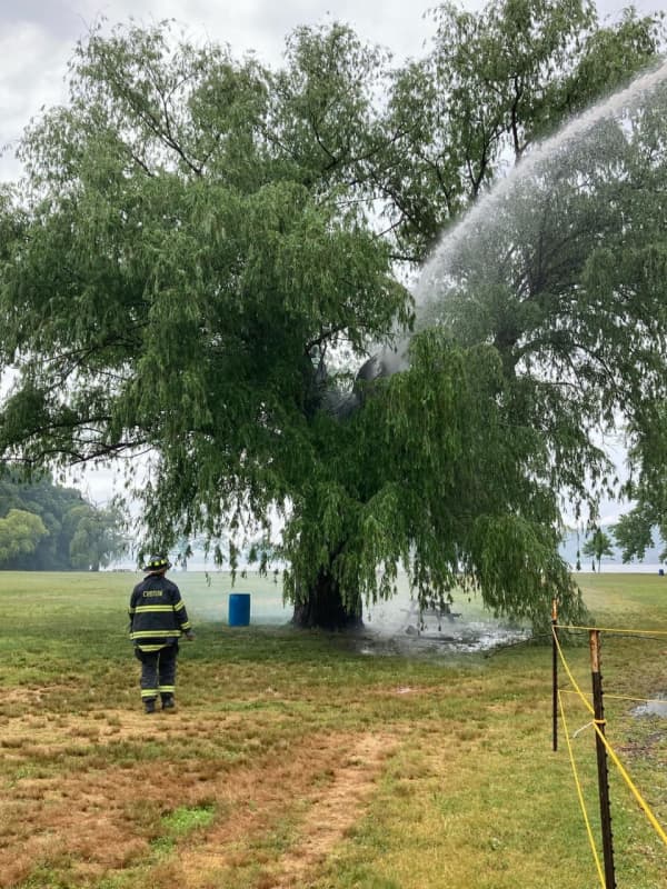
Shock Of Lightning: Storm Ignites Tree In Croton-On-Hudson Park
A crack of lightning resulting from an afternoon thunderstorm sent crews scrambling to douse a tree fire at a park in Northern Westchester. The blaze happened on Wednesday afternoon, June 14 around 2:40 p.m., when firefighters raced to Croton Point Park in Croton-on-Hudson to respond to a tree that had caught on fire after being struck by lightning. According to the Croton-on-Hudson Fire Department, crews used deck guns to extinguish the flames and were able to keep the tree intact. The Croton-on-Hudson Fire Department battles a tree fire at Croton Point Park. Croton-on-Hudson Fire …
Ulster Sullivan
News
30-Acre Wildfire Breaks Out At Minnewaska State Park In Ulster County
A lightning strike is believed to have started a large 30-acre Hudson Valley wildfire at a state park that is still burning. Some 100 state and local firefighters have been battling the Ulster County blaze at the Napanoch Point area of Minnewaska State Park in Ellenville. “I want to thank all the agencies, staff, and volunteers who have coordinated the response and assure residents that we are doing everything we can to keep people safe,” Ulster County Executive Pat Ryan said. “Conditions right now are very dry, and we must remain vigilant and careful about fires.” The fire is believed to …
Nassau
Police & Fire
Lightning Strike Causes House Fire In Elmont
A bolt of lightning that struck a Long Island home led to a house fire that was quickly knocked down by fire crews, officials announced. First responders in Elmont received an alert of a house “struck by lightning” on Monday, May 16, causing a fire on the second floor of a Circle Drive West property. The fire was reported at approximately 4:20 p.m. Upon arrival, first responders were met by smoke billowing out of windows on the second floor of the home, and crews were able to knock down the flames and declare the fire under control within an hour, shortly before 5 p.m. on Monday. No injur…
Litchfield
Weather
Severe Thunderstorm Watch Now In Effect For Region
A Severe Thunderstorm Watch is in now in effect for the entire region. The watch was issued on Tuesday, Aug. 25 at 3:10 p.m. It will last through 10 p.m. Tuesday. At 3:30 p.m., several lines of storms were moving from west to east. The main threat will be damaging winds, with gusts up to 70 miles per hour possible, the National Weather Service said. Isolated hail up to ping-pong size, downpours and frequent lightning are also possible. Earlier report - Severe Weather Alert: Storms With Damaging Winds, Heavy Rain, Possible Hail Will Sweep Through
Litchfield
Weather
Severe Thunderstorm Watch Issued With Damaging 70 MPH Wind Gusts Possible
A Severe Thunderstorm Watch has been issued for the entire region by the National Weather Service. The watch is in effect until 10 p.m. Wednesday, July 22 for the areas in yellow in the image above. Damaging winds with gusts up to 70 miles per hour that could cause power outages are the main threat. Lightning, large hail and heavy downpours are all possible. Isolated tornadoes cannot be ruled out. The time frame for the storms is from about 4 p.m. to 10 p.m. Wednesday. Earlier report - Severe Weather Alert: Storms With Strong Winds Will Sweep Through; Hail, Tornadoes Possible Che…
Litchfield
Weather
Severe Thunderstorm Watch Issued For Entire Region
The National Weather Service has issued a Severe Thunderstorm Watch for the entire region. It was issued at 1:29 p.m. Sunday, June 28 and is in effect until 8 p.m. Sunday. Showers and thunderstorms are starting to pop up across the area and are moving west to east. Some of these storms could be strong to severe with damaging winds as well as hail, frequent lightning, and heavy rainfall, the National Weather Service said. Scattered power outages are possible. Check back to Daily Voice for updates. Earlier report: More Strong Thunderstorms Expected, With Damaging Winds, L…
South Orange
Weather
Severe Thunderstorm Watch Issued For Entire Region
The National Weather Service has issued a Severe Thunderstorm Watch for the entire region. It was issued at 1:29 p.m. Sunday, June 28 and is in effect until 8 p.m. Sunday. Showers and thunderstorms are starting to pop up across the area and are moving west to east. Some of these storms could be strong to severe with damaging winds as well as hail, frequent lightning, and heavy rainfall, the National Weather Service said. Scattered power outages are possible. Check back to Daily Voice for updates. Earlier report: More Strong Thunderstorms Expected, With Damaging Winds,…
Litchfield
Weather
New Round Of Gusty Thunderstorms Could Sweep Through Area
There could be a new round of thunderstorms with drenching rain, strong wind gusts and flashes of lightning on Saturday, June 6. It will remain partly sunny into the early afternoon on another warm day in which the high temperature will be in the mid 80s. Then a cold front will approach from the northwest bringing a chance of showers and a few thunderstorms from about 2 p.m. until 6 p.m. Skies should then clear quickly with the cold front moving offshore early Saturday night. Sunday, June 7 will be picture perfect and much more pleasant with sunny skies the high temperatur…
Litchfield
Weather
Severe Thunderstorms Will Bring Wind Gusts Up To 40 MPH With Hail Possible
An approaching cold front will trigger a quick-moving round of severe thunderstorms that will bring strong winds with gusts up to 40 miles per hour. Heavy rain, thunder and lightning are expected with small hail possible. The time frame for the storm is from about 3 p.m. to 7 p.m. on Tuesday, April 21. Up to a quarter-inch of rain is expected with higher amounts in the areas where the storms were heaviest. Tuesday's high temperature will be in the upper 50s, but the ushering in of the cold front with the storm will lead to a drop in temperatures. The overnight low temperature Tuesday int…
Litchfield
Weather
Early Week Strong Storm System Could Bring Heavy Rain, Damaging Winds
A bright and breezy second half of the weekend will be followed by an early week storm system that could bring heavy rain, thunder, lightning, damaging winds and possibly hail. Sunday, April 19 will be pleasant, with clouds increasing in the afternoon after plenty of morning sunshine. It will be warmer with the temperature climbing to around 60 degrees, but winds out of the southwest with gusts up to around 30 miles per hour will make it feel cooler. It will be partly sunny on both Monday, April 20 with the high temperature in the mid 50s and again on Tuesday, April 21 leading until to the …
Greenwich
News
Two Greenwich Homes Struck By Lightning During Height Of Storm
A pair of homes in Greenwich were struck by lightning at the height of one of the rounds of thunderstorms that struck the region throughout the week. On Wednesday, Aug. 7, thunderstorms swept through the area, bringing lightning, thunder, toppling trees and taking down power lines. During that storm, Greenwich firefighters responded to two residences that appear to have been struck by lightning. Officials said that crews were first dispatched to a North Street home at approximately 7 p.m., when lightning caused minor damage to the roof of the residence, though no fire was sparked. L…
Darien
Weather
Severe Thunderstorm Watch Issued: Line Of Storms Moving West To East
With a line of storms approaching the region from the west, a Severe Thunderstorm Watch has been issued for much of the area. The watch, which went into effect just before 5 p.m. on Thursday, Aug. 8, lasts until midnight and includes Westchester, Fairfield, Putnam, Rockland, Orange and Dutchess counties. The main threat from the line of storms is wind damage with the most likely time frame for storm activity being from 8 p.m. to 11 p.m. Thursday. Some of the storms will include torrential downpours, frequent lightning and thunder. Large hail is possible. A few storms may produce damag…
Darien
Weather
Severe Weather Alert: Strong Storms Will Bring Drenching Rain, Damaging Winds
Click here for an updated story: Severe Thunderstorm Watch Now In Effect: Drenching Rain, Damaging Winds On Way Severe, gusty storms with damaging winds and drenching rain will roll through the area. Thunder, frequent lightning and local flash flooding are also expected, with large hail possible. Isolated storm activity will begin around 2 p.m. Wednesday, Aug. 7 on a mostly cloudy day in which the high temperature will be in the mid 80s. Storms will become more widespread in the late afternoon and through the evening, the National Weather Service said in a Hazardous Weather St…
Darien
Weather
Severe Weather Alert: Multiple Rounds Of Storms Will Bring Drenching Rain, Damaging Wind Gusts
Click here for an updated story: Severe Thunderstorm Watch Issued For Area: Tornadoes, Hail Possible Severe thunderstorms accompanying a cold front will bring drenching rain, flash flooding, frequent lightning and damaging wind gusts to the area, along with relief following the heat wave. The storm chance starts at around noontime on Monday, July 22, which will be mostly cloudy and much less warm, with a high temperature in the low 80. Rain showers with embedded thunderstorms will develop and move across the area starting Monday afternoon and continuing through early Tu…
Rutherford
News
Police: 6 People Displaced In Rutherford House Fire Ignited By Lightning (
Video
)
Six people were displaced in an early-morning Rutherford house fire ignited by lightning, authorities said. A Rutherford police officer was transported to the hospital for smoke inhalation after the Ridge Road fire broke out at 4:31 a.m., Sgt. Kevin Scannell said. Fire companies from Rutherford, East Rutherford, Wallington, Lyndhurst, North Arlingon, Carlstadt and Secaucus responded. Firefighters were still at the scene as of 9:15 a.m., police said. For more fire-related video, go to: Demonracer2 (YouTube)
Greenwich
Weather
New Round Of Storms Will Bring Heavy Rain, Lightning, Gusty Winds
Get set for a new round of storms. But this time, it will bring relief from the heat as a cold front arrives in the area. The front will be accompanied by thunderstorms Saturday afternoon and evening. Some of the storms will be severe and produce locally heavy rain, gusty winds, lightning and localized flooding. The storms will develop in the early afternoon before sweeping through the area starting sometime around 2 p.m. The model above projects where the storms will be at 3 p.m., with some of the storms severe (in orange). Saturday will be another hot and humid day with a high in the mi…
White Plains
Weather
Strong Storms With Heavy Rain, Lightning, Gusty Winds Moving Through Area
Scattered showers and thunderstorms are sweeping through the area late Tuesday afternoon and will continue through the evening. The isolated storms are moving from the west to the east. (See radar image above.) Some of the storms will have brief periods of heavy rain, winds gusts up to 40 miles per hour and lightning. The storm chance continues through around midnight. Storms are likely on Wednesday from about 2 p.m. to 10 p.m. as a cold front arrives. The cold front will lead to less humid conditions on Thursday, but Wednesday will be another hazy, hot and humid day with a high in the u…
White Plains
Weather
Line Of Severe Thunderstorms Headed To Area
Get set for a new round of severe storms. Late afternoon thunderstorms will once again bring downpours, lightning, gusty winds and possible flooding to the area. The line of storms is moving from west to east with torrential rainfall that may cause localized flooding. (See satellite image above.) Frequent cloud to ground lightning is occurring with this storm, according to the National Weather Service. Wind gusts up to 50 mph are possible with these storms. A Flash Flood Watch is in effect until Saturday morning for southeast New York and southern Connecticut. The chance for showers and…