Find Your Daily Voice
Tags
Follow
News
Schools
Business
Obituaries
Police & Fire
Weather
Neighbors
Lifestyle
Politics
Sports
Events
Traffic
Legal
Real Estate
Tags
Jobs
Shop
Support Us
Follow
Find Your Daily Voice
News
Schools
Business
Obituaries
Police & Fire
Weather
Neighbors
Lifestyle
Politics
Sports
Events
Traffic
Legal
Real Estate
Tags
Jobs
Shop
Support Us
Home
About us
All sites
Advertise with us
Contact us
Terms of use
Privacy policy
Code of ethics
Site Map
© 2024 Cantata Media
Tag:
Coastal Flooding
Nassau
Weather
System Sweeping Through Region With Scattered Severe Storms: Here's Latest
A storm system with rain and some severe thunderstorms is sweeping through the region from west to east. The radar image above was taken at about 7 a.m. Wednesday, May 8, shows some severe storms (marked in red). Scattered storms will persist through the morning and afternoon with some sun, pushing temperatures to the upper 70s to low 80s. Coastal flooding is expected from late Wednesday night into early Thursday morning, May 9. "Some roads and low-lying properties, including parking lots, parks, lawns, and homes and businesses with basements near the waterfront, will experience…
Arlington
Weather
Drenching Rain, 45 MPH Winds: New Storm Moving Toward Northeast
Forecasters are warning of a weekend storm bringing widespread rain and gusty winds to the Northeast, creating yet another flood risk. Thursday, March 7 will be be mild with scattered showers while Friday, March 8 will be mostly sunny with temps in the mid-50s, forecasters say. Saturday, March 9 is when the new storm will begin moving into the region with rain beginning in the afternoon and lasting overnight, according to the National Weather Service. About an inch of rain is expected to fall, which the National Weather Service says isn't much, but given an already-wet ground "there is pot…
Middlesex NJ
Schools
Middlesex County Schools Delayed Due To Major Winter Storm
Some South Jersey school districts are canceling classes or delaying the start of school before a winter storm that's expected on Tuesday, Feb. 13. The National Weather Service issued a winter storm warning for Mercer, Middlesex, and Monmouth Counties. There is also a coastal flood warning in Atlantic, Burlington, Cape May, Middlesex, Monmouth, and Ocean counties. The NWS predicts four to six inches of snow in Trenton, three to four inches in Long Branch, and one to two inches in Toms River. Southern Jersey Shore places like Atlantic City, Cape May County, Long Beach, Ocean City, and Vinela…
Sussex
Weather
Murphy Urges NJ Residents Work From Home, Stay Off Roads Ahead Of Winter Storm
New Jersey Gov. Phil Murphy is urging residents to stay off the roads ahead of a winter storm expected Monday, Feb. 12 into Tuesday, Feb. 13. The National Weather Service was predicting up to 18 inches of snow in the northernmost part of the state, with between 6 inches and a foot possible across Sussex, Warren, Morris, Hunterdon, Somerset, Passaic, Bergen, and western Essex counties, where a Winter Storm Warning was issued. Murphy said the most intense stretch of precipitation, beginning as rain and turning to snow, will happen in the middle of the night and run into mid-morning…
Atlantic
Weather
Here's Where To Find Free Parking During Winter Storm In Atlantic City
An Atlantic City casino parking garage is allowing people to protect their cars during a pre-Valentine's Day winter storm. Free parking will be allowed for Atlantic City residents and visitors at the Wave Parking Garage, the New Jersey Casino Reinvestment Development Authority (CRDA) announced. The garage is at the corner of Mississippi and Fairmount avenues. Free parking started at 4 p.m. on Monday, Feb. 12 and it will continue until 8 a.m. on Wednesday, Feb. 14. Parking will only be allowed on the second floor. CRDA offers free parking at Wave Garage for Atlantic City residents …
Atlantic
Weather
Coastal Flooding, Wind Expected From Pre-Valentine's Day Winter Storm On Jersey Shore
While many parts of the Jersey Shore won't see snow, a winter storm is expected to bring some issues right before Valentine's Day, forecasters said. According to the National Weather Service, moderate coastal flooding is forecasted from Perth Amboy to Cape May on Tuesday, Feb. 13. Minor flooding coastal flooding is expected along the Delaware Bay and Delaware River. Parts of Burlington, Cumberland, Monmouth, Ocean, and Salem counties are expected to get about an inch of snow. While inland Atlantic County could see some snow, the coast and Cape May County aren't forecasted to receive any acc…
Union
Weather
Increased Snow Projections: 18 Inches Could Fall In Parts Of NJ, PA In Major Storm, NWS Says
The National Weather Service says parts of New Jersey and Pennsylvania could see more snow than what was initially predicted due to a shift in the storm track. In an updating briefing published Monday, Feb. 12, the NWS said 12 to 18 inches of snow could fall in parts of Sussex County, NJ and the Pocono Mountains. ALSO SEE: North Jersey School Closed, Delayed Ahead Of Major Winter Storm The weather map shows between 8 and 12 inches expected in parts of Bergen, Morris, Passaic, Essex, Warren, Somerset and Hunterdon counties, where winter storm warnings have been issued. Winter weather a…
Atlantic
Weather
Coastal Flooding Possible Across South Jersey Despite Clear Skies This Week
Despite no rain or snow expected for the week ahead, forecasters are warning residents about the threat of coastal flooding across New Jersey. The National Weather Service said South Jersey will have a threat of minor flooding through 7 p.m. on Thursday, Feb. 8. A coastal flood advisory was issued for Tuesday, Feb. 6 in Atlantic, Burlington, Camden, Cape May, Cumberland, Gloucester, Ocean, and Salem counties. Minor flooding is forecasted during morning high tides in Atlantic City, Great Egg Harbor Bay at Ocean City, Cape May Harbor, and Barnegat Harbor. "While the weather will remain …
Bergenfield
Weather
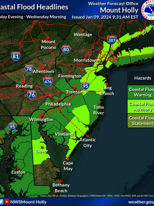
Thousands Without Power As Storm Intensifies In NJ
Thousands of New Jersey residents were without power as of Tuesday evening, Jan. 9, as the storm intensified. A State of Emergency ordered by Gov. Phil Murphy went into effect at 5 p.m., with state and local officials urging residents to stay off the roads. As of 7:25 p.m., more than 2,000 residents in Hunterdon County were in the dark, according to JCP&L, including 123 in Delaware; 729 in Lambertville City; 733 in Raritan; 437 in West Amwell, and more. In Morris County, 3,360 JCP&L customers were without power. Those are residents of Mount Olive where 2,449 people w…
Union
Weather
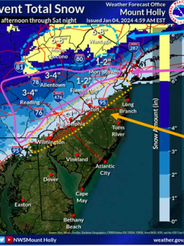
New Forecast Map: 7 Inches Of Snow Could Fall In Parts Of NJ This Weekend
Some parts of New Jersey and the Lehigh Valley/Pocono mountains could get up to seven inches of snow this weekend, according to newly-released forecast maps. The National Weather Service's Mount Holly office released a new forecast map on Thursday, Jan. 4 — two days before heavy snow is expected to make its debut after nearly two years in the Northeast. ⚠️❄️ A coastal system will bring widespread precipitation to our region. Snow and some mixed precip will occur northwest... Posted by US National Weather Service Philadelphia/Mount Holly on Thursday, January 4, 2024 ⚠️ A lot of …
Arlington
Weather
Pre-Thanksgiving Storm Update: Here's What To Expect
A pre-Thanksgiving storm was expected to ramp up Tuesday evening, Nov. 21 —with some travelers already en route. According to the Baltimore/Washington National Weather Service, light rain across the region is expected to become heavier into the evening hours, marking the first soaking rainfall in nearly two months. A coastal flood warning was issued across much of the region for Tuesday evening, Nov. 21. Up to three inches of rain could fall across the DMV, the NWS says. 2:53pm-A slow go for travelers this afternoon with widespread moderate to heavy rainfall across the region. The ra…
Middlesex NJ
Weather
Warm Start To Spooky Season Expected After NJ Can Get Itself Out From Under Water
We're going from one wacky weather pattern to another this weekend. New Jersey has one more day of drizzle before the skies begin to clear up, forecasters say. And when they do, the region will be in for another type of unseasonable weather. On Saturday, Sept. 30, several homeowners, particularly along the Jersey Shore, were left with several feet of water, which also lingered on roadways across the state. The rest of the day will be cloudy and cool, and not nearly as bad for precipitation, the National Weather Service says. Lingering coastal flooding with times of high-tide could make it…
Capital District
Weather
Update: New Tropical Storm To Bring Drenching Rain, Strong Winds To Region; Tornadoes Possible
A newly named tropical storm that has formed off the coast of North Carolina will bring heavy rain that could cause flooding along with strong wind gusts to much of the Northeast this weekend. New update - Tropical Storm Ophelia Makes Landfall, Moves North, Will Bring Heavy Rain, Strong Winds To Region Tropical Storm Ophelia is packed with winds of about 60 miles per hour and was about 185 miles south of Cape Hatteras, North Carolina, shortly after it strengthened in the middle of the afternoon Friday, Sept. 22, according to the National Hurricane Center. Isolated tornadoes are poss…
Berks
Weather
Events Postponed, Advisories Issued Across Southeast PA Ahead Of Storm
As National Weather Service meteorologists issue advisories ahead of the weekend's forecasted tropical storm, officials across greater Philadelphia are tweaking their schedules to accommodate. The potential tropical cyclone is expected to bring strong gusts of wind, periods of rain, and "moderate to major" coastal flooding from 4 a.m. Saturday, Sept. 23, to 10 p.m. Sunday, Sept. 24, according to the NWS Mount Holly station. The brunt of the storm is expected to affect coastal areas, but southeast Pennsylvanians should expect up to 2.75 inches of rainfall over the weekend, and gu…
White Plains
Weather
Nor'easter: Potent Storm With Gusty Winds Brings Mix Of Snow, Rain, Causes School Closures
A multi-threat Nor'easter packed with strong winds, and a mix of snow and rain, has arrived in the region, leading to scores of school closures on Tuesday, March 14. The storm will linger into early Wednesday morning, March 15, according to the National Weather Service. Rain that began Monday evening became steadier overnight with steady snowfall in areas farther north and inland. For the latest snowfall projections see the first image above from AccuWeather.com: 1 to 3 inches (light blue) 3 to 6 inches (Columbia blue) 6 to 12 inches (Royal blue) 12 to 18 inches (blue) 18…
White Plains
Weather
Strong Winds From Powerful Nor'easter Could Cause Power Outages: Here's Latest
Updated story - Storm Watch: These Areas Expected To See Extreme, Major Impacts From Nor'easter A potent Nor'easter that could dump as much as 18 inches of snow in some inland areas will be packed with strong winds that could cause power outages. The time frame for the storm is Monday night, March 13 into late Tuesday evening, March 14, according to the National Weather Service. Wind gusts will range from 40 to 70 miles per hour starting Monday night, March 13. (See the first image above from AccuWeather.com.) Areas most at risk for power outages due to fallen trees and power lines a…
White Plains
Weather
Here Are Updated Snowfall Projections For New Winter Storm Headed To Northeast
Updated snowfall projections have been released for a new winter storm headed for the Northeast that will bring a mix of rain, sleet, and snowfall. The current projected time frame for possible snowfall is from Friday evening, March 3 into Saturday, March 4, the National Weather Service says. Precipitation is expected to start shortly after nightfall Friday, with sleet and snow inland. Areas near the coast could see heavy rainfall, coastal flooding, and strong winds with gusts up to 45 miles per hour. The highest snowfall totals will be farther north and inland, mainly north…
White Plains
Weather
Track Shifts For Winter Storm Taking Aim On Northeast: New Projected Snowfall Totals
The projected track has shifted for a new winter storm headed for the Northeast as an unsettled weather pattern arrives in the area. The current projected time frame for possible snowfall is from Friday evening, March 3 into Saturday, March 4, the National Weather Service says. Precipitation is expected to start as rainfall Friday afternoon, before changing over to a wintry mix and snow, especially in areas farther north and inland. Areas near the coast could see heavy rainfall, coastal flooding, and strong winds with gusts up to 45 miles per hour. The highest snowfall totals will be&…
Lehigh
Weather
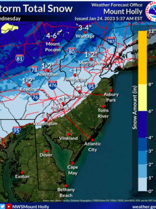
First Storm Of Season Bringing Snow, Gusty Winds To Much Of NJ, Eastern PA
The first storm of the season is shaping up for parts of New Jersey and eastern Pennsylvania, with snow and gusty winds expected all day Wednesday, Jan. 25. The National Weather Service issued a winter weather advisor for Morris, Sussex, Warren, western Passaic counties, Berks, Lehigh, Monroe and Carbon counties, from 7 a.m. to 7 p.m. Summary of weather hazards for the Wednesday winter storm. Snow, mixed precipitation, strong winds, coastal flooding, and marine impacts area all expected. Posted by US National Weather Service Philadelphia/Mount Holly on Tuesday, January 24, 2023 The wes…
Suffolk MA
Weather
Power Outages, Flooding Possible For Eastern Massachusetts Later This Week
A pre-Christmas wintry mix could bring power outages, coastal flooding and damaging winds to Eastern Massachusetts as early as Thursday, Dec. 22. Here's a summary of hazards/timing for the upcoming storm. Keep in mind bitterly cold air will follow behind the storm Friday night/Saturday. #ctwx #mawx #riwx pic.twitter.com/nislL6mvu0 — NWS Boston (@NWSBoston) December 22, 2022 The National Weather Service (NWS) expects widespread coastal flooding to impact parts of Eastern, Northeastern and Southeastern Massachusetts from Thursday night to Friday afternoon. [Strong and Potentially Dam…
White Plains
Weather
Tropical Rainstorm Could Bring Heavy Rain, Strong Winds To Region
A tropical rainstorm developing off the East Coast will put a damper on the region's second half of the weekend. The system is on track to arrive in this region during the day on Sunday, Oct. 23, with potentially heavy rainfall and damaging winds Sunday night into Monday morning, Oct. 24, according to the National Weather Service. “If the storm hugs the coast, it would push rain into the Philadelphia area Sunday morning and into New York City and Boston by Sunday afternoon," AccuWeather Senior Meteorologist Dean DeVore said. "But, if the storm develops to its full potential, it c…
Greenburgh
Weather
Here's When To Expect New Round Of Rain From Ian In Much Of Region
Much of the region will see a new round of rain from the remnants of Ian in the second half of a gray, raw, and blustery weekend. Sunday, Oct. 2 will be cloudy throughout the day with a high temperature of around 60 degrees and intermittent rainfall at times, especially in the early afternoon, mainly in areas farther south, especially in New York City and surrounding areas. A look at those areas is shown in the image above, including where coastal flooding is possible. "Widespread minor flooding of vulnerable areas is expected near the waterfront and shoreline, including roads, p…
Mercer
Weather
Weekend Washout? Here's The Latest Memorial Day Weather Outlook
Well, it wasn't the Memorial Day holiday weekend most of us hoped and planned for. Cloudy skies, blustery, howling winds, on-and-off-showers -- none of the sights we usually see this time of year. Near record cold-high temperatures are expected, with highs in the 50s and lows in the 40s, the National Weather Service's Mount Holly office says. Continued drizzle is likely Sunday, possibly tapering off at night. Light winds Saturday and coastal flooding are both likely, forecasters say. "If the official high temperature in Philadelphia and Washington D.C., does not make it out of the lower …
Chester
Weather
Storm
Watch
: 50 MPH Winds, 2 Feet Of Snow On The Way
The most impactful part of the winter storm slamming the Northeast was expected Monday afternoon, with gusty winds and up to two feet of snow on the way. Between 3 and 6 inches of snow had already fallen as of 11 a.m. in parts of Eastern PA and North/Central Jersey, the National Weather Service reports. The sleet and freezing rain falling in some areas will soo change back to snow, a heavy band expected to drop between 12 to 24 inches across North Jersey and Eastern Pennsylvania, the NWS said. It was unclear how much snowfall was expected in Greater Philadelphia and Central Jersey. Those n…
Nassau
Weather
Chances Increase For Potentially Major Snowstorm To End January, Start February
The chances have increased for a potentially major snowstorm that will end the month of January and usher in February, bringing a half-foot or more of accumulation. The storm moving west to east is expected to arrive on Sunday, Jan. 31, and linger into Tuesday, Feb. 2. (See the first image above.) The National Weather Service in a Hazardous Weather Outlook statement issued early Thursday morning, Jan. 28 that the storm could bring 6 or more inches of snow to the area late Sunday night into Tuesday. 'Strong Northeast winds, coastal flooding, and beach erosion will be po…
Bucks
Weather
Latest Snowfall Predictions, Timing Of Powerful Winter Storm Headed To NJ, PA This Afternoon
New Jersey and Pennsylvania are expected to see the first winter storm Wednesday afternoon into Thursday morning. Precipitation will begin early Wednesday afternoon in South Jersey, then head north to Central Jersey and Philadelphia, where 6 to 12 inches of snow are predicted, the National Weather Service says. Strong winds and heavy sleet were likely across South Jersey and Philadelphia, with a chance of rain leading along the Jersey Shore. Coastal flooding was possible, especially late Wednesday night and early Thursday morning, meteorologists say. Snowfall is expected to begin in N…
Montgomery PA
Weather
Latest Snowfall Predictions, Timing Of Powerful Winter Storm Headed To NJ, PA This Afternoon
New Jersey and Pennsylvania are expected to see the first winter storm Wednesday afternoon into Thursday morning. Precipitation will begin early Wednesday afternoon in South Jersey, then head north to Central Jersey and Philadelphia, where 6 to 12 inches of snow are predicted, the National Weather Service says. School districts have already started announcing snow days (click here for Montgomery County, PA districts closed, here for Bergen/Passaic, and here for Morris/Sussex). Strong winds and heavy sleet were likely across South Jersey and Philadelphia, with a chance of rain leading along…
Nassau
Weather
Major Storm Will Bring Heavy Rain, Strong Winds That Could Cause Power Outages
A post-Thanksgiving storm will hit the region with heavy rain and strong wind gusts that could cause power outages. The time frame for the storm is Monday, Nov. 30 into Tuesday, Dec. 1. The days leading up to the arrival of the system will be dry with temperatures continuing to be above normal through the weekend with daily highs ranging from the low to upper 50s. It will remain fairly cloudy on Black Friday, Nov. 27, but with no precipitation, according to the National Weather Service. While a stray shower can’t be ruled out on Saturday, Nov. 28, it should also be dry through Sunda…
Litchfield
Weather
Here's New Projected Timing, Track For Hurricane Teddy, How It Will Affect Parts Of Region
Hurricane Teddy's latest projected path takes the center of the storm well east of the region, but it will still be felt in parts of the area. Minor to moderate coastal flooding (from half a foot to 2 feet of inundation depending on location) is expected at the times of high tide through Sunday afternoon, Sept. 20. Additionally, high surf of 8 to 12 feet and dangerous rip currents at ocean beaches will also occur, the National Weather Service said. Earlier report - Teddy Strengthens Over Atlantic, Expected To Be Major Hurricane Teddy was one of the final named storms from the English…
Nassau
Weather
Tracking Isaias: Strong Winds That Could Cause Power Outages, Possible Tornadoes Among Threats
This story has been updated. The eye of Tropical Storm Isaias is expected to track near the New York/Connecticut border after it arrives in the region on Tuesday afternoon, Aug. 4. Drenching rain may lead to flooding and winds between 35 to 45 miles per hour with gusts as high as 60 to 65 mph could cause power outages. In addition, the storm may be accompanied by isolated tornadoes, especially near coastal areas. The time frame for Isaias' strongest impact in this area is early Tuesday afternoon, with the storm moving at a faster pace than earlier predicted. A Tropical Storm Warning and …
Darien
Weather
Flash Flood Watch: Significant Storm System Will Bring Downpours, Delay Holiday Travel
A significant storm system in the pre-Christmas travel days at the end of the week is headed our way. Heavy rain, wind, and coastal flooding are all likely. A Flash Flood Watch is now in effect from 1 a.m. Friday, Dec. 21 until 1 a.m. Saturday, Dec. 22. The National Weather Service is now forecasting 1.5 to 2.5 inches of rain with locally higher amounts, especially in any thunderstorms, with most of the area in a marginal risk for excessive rainfall. It looks to be too warm for any snow across the region. The forecast will be fine-tuned with amounts and when to expect the heaviest r…
1
Archive